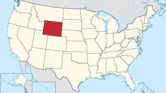
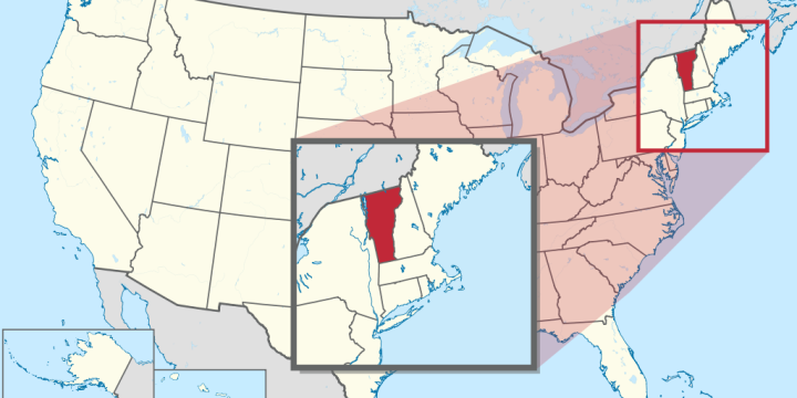
State of Vermont

State of Vermont

Geography
Capital city Montpelier Biggest city Burlington Surface 24,923 km² Population 646,000 Length of highway network 589 km First highway 1958 Abbreviation VT Vermont is a state in the United States. The state is located in the northeast of the country, and has 646,000 inhabitants (2021). The capital is Montpelier, the largest city is Burlington. The state has an area of 24,923 square kilometers and is more than half the size of the Netherlands. Geography I-91. Vermont is a rural state in the northeastern United States, part of the New England region. The state borders Canada, on the province of Québec. It also borders the states of New Hampshire, Massachusetts and New York. The state measures a maximum of 250 kilometers from north to south and a maximum of 150 kilometers…
Read More
State of Virginia

State of Virginia

Geography
Capital city Richmond Biggest city Virginia Beach Surface 110,786 km² Population 8,642,000 Length of highway network 2,394 km First highway 1941 Abbreviation VA Virginia is a state in the eastern United States. The state is located on the Atlantic Ocean and has 8.6 million inhabitants (2021). The capital is Richmond and the largest city is Virginia Beach, part of the Hampton Roads conurbation. The state has an area of 110,785 square kilometers and is almost 3 times the size of the Netherlands. Richmond, the capital of Virginia. Geography Virginia is located on the east coast of the United States, although the open sea coastline is relatively short relative to the size of the state. The state is bordered by North Carolina and Tennessee to the south, Kentucky and West Virginia…
Read More
State of Washington

State of Washington

Geography
Capital city Olympia Biggest city Seattle Surface 184,827 km² Population 7,738,000 Length of highway network 1,555 km First highway 1940 Abbreviation WA Washington is a state in the northwestern United States. The state's nickname is the Evergreen State, and its capital is Olympia. The largest city is Seattle. The state itself has 7.7 million inhabitants (2021). The state is often referred to as Washington State, to distinguish it from the capital Washington, DC Geography I-90 at the Columbia River. Washington is part of the Pacific Northwest region, and is located on the Pacific Ocean. The state has a long border with Canada, on the province of British Columbia, and further borders the states of Idaho to the east and Oregon to the south. Washington measures a maximum of 570 kilometers…
Read More
State of West Virginia

State of West Virginia

Geography
Capital city Charleston Biggest city Charleston Surface 62,755 km² Population 1,783,000 Length of highway network 924 km First highway 1954 Abbreviation WV West Virginia is a state in the United States. The state is located in the east of the country and has 1.7 million inhabitants (2021). The capital and largest city is Charleston. The state measures 62,755 square kilometers, making it more than twice the size of the Netherlands. Geography US 48 at Moorefield. Located in the Appalachian Mountains, West Virginia is a little tricky to place geographically, as it doesn't really fall under the East Coast, Northeast, Midwest, or South. The state borders Pennsylvania, Maryland, Virginia, Kentucky and Ohio. The state has a distinctive shape and measures a maximum of 360 kilometers from north to south and 350…
Read More
State of Wisconsin

State of Wisconsin

Geography
Capital city Madison Biggest city Milwaukee Surface 169,790 km² Population 5,896,000 Length of highway network 1,915 km First highway 1953 Abbreviation WI Wisconsin is a state in the northern United States. The state is located in the Great Lakes region, and has 5.8 million inhabitants (2021). The capital is Madison, the largest city is Milwaukee. The state has an area of 169,790 square kilometers and is therefore more than four times the size of the Netherlands. I-41 between Oshkosh and Fond du Lac. Geography Wisconsin is located on the western side of the Great Lakes region, which has a shoreline on Lake Michigan and Lake Superior. The state borders Michigan, Illinois, Iowa, and Minnesota. The state measures a maximum of 500 kilometers from north to south and 470 kilometers from…
Read More
State of Wyoming

State of Wyoming

Geography
Capital city Cheyenne Biggest city Cheyenne Surface 253,348 km² Population 579.000 Length of highway network 1,473 km First highway 1958 Abbreviation WY Wyoming is a state in the United States. The state has 579,000 inhabitants (2021) and the capital and largest city is Cheyenne. Geography City Population Cheyenne 65,000 Casper 59,000 laramie 32,000 Gillette 31,000 Wyoming is located in the western United States, on the transition from the High Plains to the Rocky Mountains. The state clockwise borders Montana, South Dakota, Nebraska, Colorado, Utah, and Idaho. The state has boundaries along latitudes and longitudes, forming a square with them. The state measures 600 kilometers from west to east and 440 kilometers from north to south. It is the ninth largest state in the United States by area. The Rocky Mountains…
Read More
Fresno, California

Fresno, California

Geography
  Fresno City in the United States Location State California County Fresno County Coordinates 36°46'54"N, 119°47'32"WL General Surface 297.07 km² - country 296.34 km² - water 0.73 km² Residents (April 1, 2020) 542,107 (1829 inhabitant/km²) Politics Mayor Jerry Dyer (R) Website fresno.gov The center (downtown) of Fresno Portal United States California According to iamaccepted, Fresno is a city in the middle of the US state of California and the county seat of Fresno County. The city is located in the San Joaquin Valley, which is part of the Central Valley, and had an estimated population of 527,438 in 2017. It is the largest city in California's San Joaquin Valley, the 34th largest city in the country (behind Tucson). and ahead of Sacramento) and fifth by state (behind San Francisco and…
Read More
Salt Lake City, Utah

Salt Lake City, Utah

Geography
Salt Lake City, the capital and largest city of the US state of Utah, is located on the southeastern shores of the Great Salt Lake. It was founded in the middle of the 19th century by the Mormon prophet Brigham Young, who brought his religious community here to the promised land. To this day, Salt Lake City is the headquarters of the Mormon Church. Welcome to Deseret State The Shoshone, Ute and Paiute Indian tribes were the original inhabitants of the area where present-day Salt Lake City is located. Europeans arrived in these places only in the middle of the 19th century. It was 1847 when a group of 148 Mormons led by Brigham Young (1801-1877) came to the shores of the Great Salt Lake from Missouri. Young was the…
Read More
Aberdeen, South Dakota

Aberdeen, South Dakota

Geography
To the northeast of the capital Pierre, in the flat landscape of South Dakota, lies the town of Aberdeen, which is the county seat of Brown County. The city currently has around 27,000 inhabitants, but the entire metropolitan area, which also includes the surrounding regions, has approximately 40,000 inhabitants. According to existingcountries, Aberdeen is located in the northeastern part of the state, in the valley of the James River, which is dammed by two reservoirs near the city. The peaceful Moccasin Creek flows through the city, which then flows into the James River. The first settlers of the area were the Sioux Indians around 1700-1879. The first white settlers came to the county in the first half of the 19th century, mainly for the fur trade. They established many trading…
Read More
About International Telecommunications Union (ITU)

About International Telecommunications Union (ITU)

Acronyms, Geography
Short for International Telecommunication Union according to abbreviationfinder, the ITU is the specialized agency of the United Nations for information and communication technologies – ICT. It is headquartered in Geneva, Switzerland, and has 12 regional and area offices around the world. ITU currently has 193 member countries and more than 700 private sector entities and academic institutions. The beginning On September 3, 1932, the joint meeting of the XIII Conference of the International Telegraphic Union UTI, created in Paris on May 17, 1865, and the III Conference of the International Radiotelegraphic Union URI began in Madrid, Spain, and on the 9th On December of the same year, by virtue of the agreements reached at said meeting, the Agreement was signed by which the International Telecommunications Union was created, which in…
Read More
National University of Jujuy (Argentina)

National University of Jujuy (Argentina)

Education, Geography
National University of Jujuy (UNJ or UNJu). National public university of Argentina, located in San Salvador de Jujuy, province of Jujuy. Founded in 1973, it has four faculties and five institutes. Historical review Since its birth, in 1972, as the Provincial University of Jujuy, nationalized in 1974, the UNJu has been in constant growth. To fulfill its mission, it has four Faculties, two Research Institutes and the "Dr. Horacio Carrillo" School of Mines that operate in buildings distributed throughout the city of San Salvador de Jujuy. Within the UNJu the student has classrooms, laboratories, libraries and other facilities necessary to optimize their performance. The equipment is a constant concern of the university community, knowing that obtaining excellence is also supported by a broad and efficient structure. College Composition The UNJu…
Read More